
About the Watershed
Table of Contents
Land Management
Entities with land management responsibility over the watershed include the State Department of Parks and Recreation; California Department of Fish and Wildlife; Golden Gate Bridge and Transportation District; Marin Water; and Marin County Parks Department. There are also several public-school districts that are free from local jurisdiction, although they are expected to follow state and federal regulations protecting natural resources and air and water quality.
Land Use Categories
Land use falls into five broad categories:
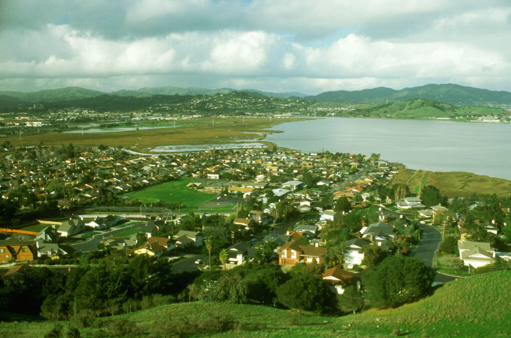
Suburban Development
Private property is under the jurisdiction of the incorporated communities of Corte Madera, Fairfax, Larkspur, Ross, and San Anselmo or the County of Marin.
Urban Development
This is a mixture of private and public property and includes residential and commercial uses.
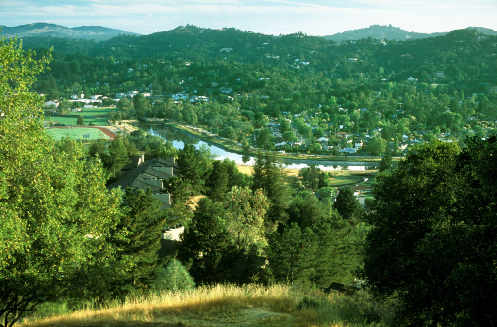
Open Space or Resource Protection
Marin Water manages a significant part of the upper reaches of the southern and western sides of the watershed. All or part of eight Open Space Preserves managed by Marin County Parks are in the watershed; these areas are also in the upper reaches of the watershed. Sorich Ranch Park is managed by the Town of San Anselmo. A small part of Mount Tamalpais State Park is within the watershed. The California Department of Fish and Wildlife manages the Corte Madera Ecological Reserve, located south of the Ferry Terminal along San Francisco Bay.
Developed Parks
Creekside Park, including the multi-use path along the creek, is a county park located in Kentfield; the Corte Madera Creek Path, also managed by Marin County Parks, follows the creek from the Ferry Terminal upstream into the Town of Ross. Deer Park in Fairfax is managed by Marin Water. Local communities maintain several parks within the watershed, nearly all of which are along creeks: Peri Park in Fairfax; Faude, San Anselmo Memorial, Creek, and Robson-Harrington parks in San Anselmo; Natalie Coffin Greene Park, Frederick Allen Park, and Ross Common in Ross; Piper, Dolliver, Magnolia, Hamilton, Bon Air Landing, Niven, and Remillard parks in Larkspur; and Town, San Clemente, and Granada parks in Corte Madera.
Schools
Three high schools and numerous middle schools and elementary schools are near streams. Corte Madera Creek passes through the College of Marin Kentfield campus.
Regulatory Authority
Regulatory authority for biological resources is exercised by the California Department of Fish and Wildlife and three federal agencies: U.S. Army Corps of Engineers, U.S. Fish and Wildlife Service, and NOAA Fisheries. Agencies dealing with water resources include the Environmental Protection Agency, California Environmental Protection Agency, and California Water Resources Control Board (both the Division of Water Rights and the Regional Water Quality Control Board). Some kinds of activities may involve the San Francisco Bay Conservation and Development Commission and/or the State Lands Commission. The State Department of Water Resources Division of Dam Safety has jurisdiction over repairs or changes to the dam at Phoenix Lake.
Regulations that apply state-wide and that are implemented by state and federal agencies include the Clean Water Act, the federal Endangered Species Act, the California Endangered Species Act, and the California Native Plant Protection Act. Marin County, each of the incorporated communities, and Special Districts within the watershed have some planning and land use tools that can be used to protect the integrity of the watershed. They may include such things as setbacks for development along drainages, policies for the protection of large trees, or other measures implemented at the discretion of local jurisdictions.
Jurisdictions with land use and planning authority within the watershed include the State of California, Marin County, and the incorporated communities of Corte Madera, Fairfax, Larkspur, Ross, and San Anselmo. Some of the Special Districts with planning authority in the Watershed include the Marin Water, Marin County Parks, Marin County Water Conservation and Flood Control District, and the Golden Gate Bridge, Highway and Transportation District. The Ross Valley Sanitation District owns limited land, but it owns and maintains the sewer system that serves the watershed, an important part of the infrastructure.
Urbanization Issues
Urbanization not only affects habitat in obvious ways–for example, direct loss of habitat, channelization of streams, degradation of water quality, and dewatering of streams–but it can also affect habitat in more subtle ways by altering and disrupting ecosystem processes that can have unintended impacts to aquatic ecosystems through increased flooding, channel erosion, landslides, and aquatic habitat destruction. It is impossible to separate the overlapping and interrelated impacts of urbanization; however, the following broad categories are used to provide more detail. Friends of Corte Madera Creek Watershed addresses all of these issues in its work.
Alteration of Natural Vegetation
Urbanization causes severe and permanent alteration of the natural vegetation when the vegetation is removed or converted to buildings, pavement, lawns, and ornamental plants. In upland areas urbanization contributes to erosion and altered drainage, often reducing infiltration and increasing surface runoff. Impacts are particularly severe in riparian corridors, that under natural conditions are extremely rich in wildlife. Vegetation is commonly removed to increase the visibility of and access to streams and to allow the installation of landscaping and structures near the tops of stream banks. Loss of riparian vegetation reduces inputs of beneficial nutrients, recruitment of large woody debris, and stream-bank stability and increases the input of sediment and other pollutants in runoff by reducing the filtering effect of vegetation. It also leads to an increase in stream temperature by removing much of the overhead canopy. In spite of these impacts, what remains of our creek corridors constitutes a refuge for native trees and wildlife on the valley floor.
Disrupted Hydrological Processes and Reduced Stream Complexity
Construction and landscaping near streams are often followed by the installation of retaining walls and other hard structures intended to protect or enlarge developed areas. In downtown San Anselmo, buildings hang over San Anselmo Creek and foundations rest on the creek bed. The course of Fairfax Creek was altered and it was buried in a culvert, apparently to provide more buildable area near the center of town. These activities result in severely constricted streams with disrupted or altered hydrological and riparian processes. Furthermore, in developed areas, much of the surface soil is covered by impervious surfaces (buildings, parking lots, roads), which increase peak flows and change channel characteristics. These changes increase the maximum discharge associated with floods and increase the frequency of flooding.
San Anselmo Creek, like many degraded urban streams, has a relatively uniform bed, with few pools or riffles, exposed near-vertical banks down-cut by several yards, chronic high sediment loads, is deficient in woody debris, and has severely reduced numbers of aquatic organisms compared to nearby undeveloped streams.
Clearing of vegetation, compaction of soil, installation of roads and other impervious surfaces, and direct interception of subsurface flows by drains damage watershed hydrology. Impervious areas increase winter peak flow and block infiltration into the soil. This results in a reduced groundwater storage and lower summer base flows.
Impared Water Quality
Urban non-point source pollution includes heavy metals, pesticides, bacteria, organics (oil and grease), dirt, and nutrients. In urbanized streams, the type and quantity of nutrients can change significantly. The important function of large woody material and leafy detritus in providing nutrients in natural streams is taken over by excessive nutrient loading from sewage and runoff from roads and landscaped areas. The principal effect of excess nutrients upon a stream is the stimulation of algae and other aquatic plant growth, such as can be seen in the lower reaches of Corte Madera Creek during the spring and summer. Water quality testing in our watershed shows high concentrations of E. coli in some locations, especially in the summer.
Measurement of water temperature show elevated temperatures throughout the watershed during the summer. The warmest water, which is lethal to young steelhead, has been observed in the upstream end of the concrete flood control channel. Several habitat changes caused by urbanization can affect stream temperatures. Loss of riparian vegetation and increased channel width increase the area of unshaded stream surface area, and reduced water depths further contribute to heat loss or gain, increasing diurnal temperature fluctuations. Stream temperatures in urban areas may also be indirectly affected by changes in hydrology, channel morphology, and microclimate. Lower summer base flows resulting from reduced infiltration can also contribute to higher water temperatures.
Barriers to Fish Passage
Urban development is characterized by high road densities, and the resulting bridges, culverts, and other structures constrain channels and impede fish migration in a variety of ways. The most significant barrier to passage for fish in our watershed is the concrete flood control channel in Kentfield and Ross. It is a velocity barrier for spawning steelhead at high flows because the resting pools are too small and tend to fill with gravel. The channel is a thermal barrier to smolts as they attempt to swim to the ocean. Other barriers include a very long culvert under downtown Fairfax and various poorly designed fish ladders, weirs, and small dams throughout the watershed. Areas of high temperature and poor water quality can also present barriers to passage.
Degraded Biological Diversity and Habitat Suitability
The abundance and diversity of aquatic organisms are greatly altered by urban impacts. The key to protecting and restoring urban streams appears to be reducing the imperviousness of surfaces associated with urban development and protecting channel integrity and riparian vegetation. It has been observed that stream quality impairment is first observed when watershed imperviousness reaches 15% of the total watershed and becomes severe at 30%. For stream ecosystems containing self-sustaining steelhead populations, some experts recommend that watershed imperviousness should not exceed 10%. At this level, creek flows are not radically changed, and minor pollutants can be filtered out by vegetation and soil. Reducing the amount of runoff and minimizing landscape disturbance also can reduce urban impacts to habitat quality. Efforts to establish the impervious area of our watershed have not been successful–they are labor intensive and there has not been adequate funding to perform the assessment.