
Creek Chronicles, our biannual newsletter, is another important way we share information. Friends also regularly comments on proposed planning and construction projects that could affect the watershed, advocating for its ecosystem and natural resources.
Download the Current Issue of Creek Chronicles
Selected Articles from Current Issue
The Recreation of a Creek
by Sandy Guldman, 2026
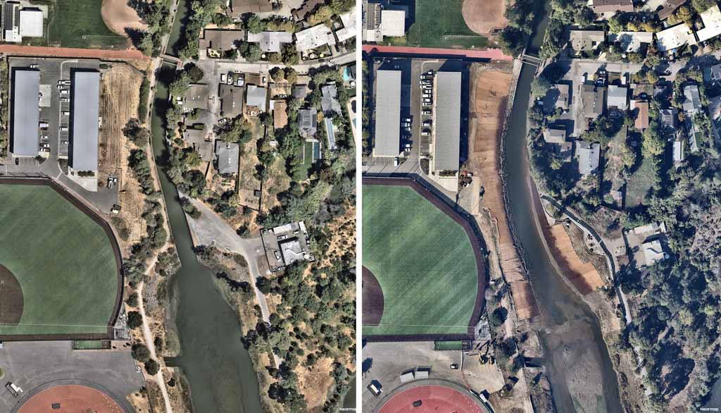
In the late 1960s the U.S. Army Corps of Engineers constructed a mile-long concrete channel, encasing a partially tidal section of Corte Madera Creek in Kentfield, with the goal of reducing flooding in the Ross Valley. It proved to be ineffectual, unpopular, and fatal to the migration of coho salmon.
The thought of removing it was daunting but persistent, so Friends of Corte Madera Creek decided to focus on a small, feasible downstream project. In 2017 Friends hired Geomorph Design Group, headed by Matt Smeltzer, to prepare a conceptual plan for modifying the concrete channel where it passed through the College of Marin and Kent Middle School campuses.
Using that plan to obtain grants to fund the initial design was successful and, by 2022, a project located downstream of Stadium Way, resilient to sea-level rise and with 1.8 acres of recreated wildlife habitat, was designed, permitted, and shovel-ready. That could not have happened without the close cooperation of the Marin County Flood Control and Water Conservation District, College of Marin, and the Coastal Conservancy. Matt Smeltzer and others, including Scott Walls, Brian Shedden, Prunuske Chatham Inc., Stetson Engineers and Miller Pacific prepared the design and specifications.
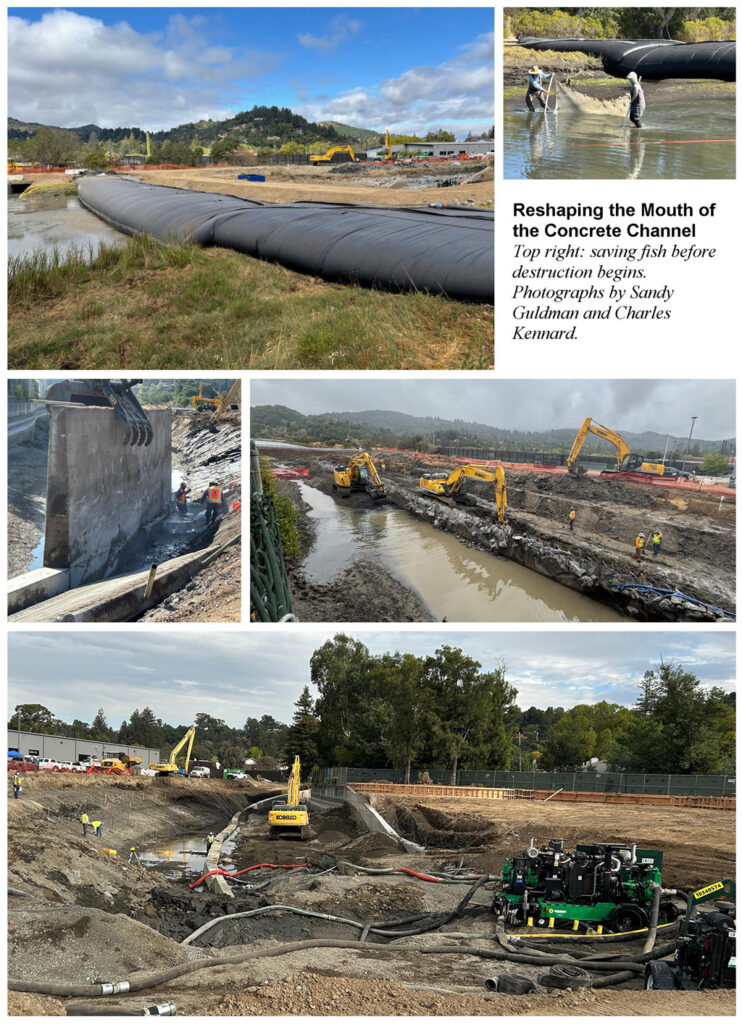
Most of the construction funding was provided by the California Coastal Conservancy and Department of Water Resources. The Flood Control District issued a Request for Bids, and the contract was awarded to Ground Control Inc. Because of time constraints for protecting the endangered Ridgway’s rail and in anticipation of the rainy season, active construction began on September 1, 2025, and in-channel work had to be completed by mid-October.
A crew was ready to install an Aquadam™—a long flexible bag pumped full of water from the creek—just downstream of the work area, when work stopped to allow a harbor seal take its own time to leave the mouth of the channel. When installed, the dam prevented tidal flows from entering the work area; a similar, smaller dam was installed upstream of the Stadium Way bridge. De-watering began as soon as the dams were in place, and when the water was low enough the fish between the dams were rescued using a seine net, counted, and released downstream. Many tidal marsh plants had also been previously salvaged, to be replanted later.
The six-week construction window was very short, so multiple crews working 12-hour days set a brisk pace. The existing upland trees and shrubs—almost exclusively non-native—in the work area were removed, followed immediately by excavation behind the right wall (when looking downstream). In short order, the wall was lowered by a combination of breaking off sections and saw cutting. The sawcut walls were capped with a specially formulated concrete mix to keep saltwater from infiltrating and corroding the remaining parts of the walls, most of which are now permanently under water.
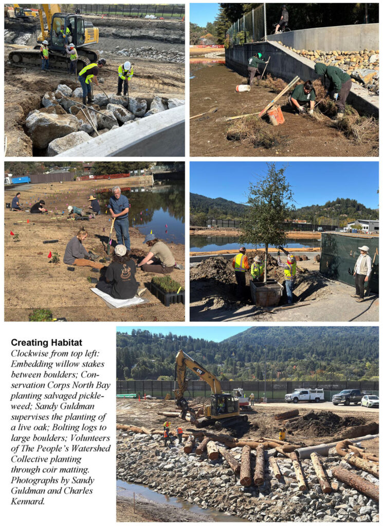
Boulders weighing up to two tons were installed to stabilize the right bank. Where these were adjacent to the remaining concrete wall, arroyo willow stakes gathered in Ross were inserted between the rocks, and bedded in soil. A layer of cobbles was added, and within two weeks the stakes had sprouted!
Downstream, on an outside curve, the crew bolted large logs to the bigger boulders. The logs serve two purposes: they protect the bank from erosion and they provide high flow refugia for fish, especially steelhead trout, and other aquatic organisms. When the tide rose, mallards and a cormorant immediately used the logs as safe places to rest.
After a rain October 12, the work area filled with water, but fortunately, the in-channel earthwork was complete so the coffer dams were removed. The large dam was slit open and drained; as it emptied and became more buoyant, the end on the left bank was released, and the bladder was pulled out of the creek by an excavator.
During this same period, a sinuous retaining wall on the left bank was formed and poured. It supports a thick layer of liquifiable sand under a parklet next to the multiuse path. A newly-planted live oak has been joined by benches.
All open soil on the gently sloping banks was covered by coconut fiber mats to prevent erosion while new vegetation takes hold. Planting was funded by a grant from the National Fish and Wildlife Foundation, supplemented by funds from the Larkspur Marina Property Owners Association to compensate for wetland impacts of lagoon bulkhead repair.
On November 10, a Conservation Corps North Bay crew began installing more than 6,000 plants, nearly all grown for Friends by The Watershed Nursery of Point Richmond. The work involves cutting slits in the mats, so it is time-consuming. An experienced volunteer group led by Audrey Fusco has also been of great assistance in planting.
As of this writing, fencing is being installed. Most of the upland plants have been installed and the CCNB crew, supervised by Prunuske Chatham, is adding mulch, browse protection cages, and temporary drip irrigation. The Flood Control District is responsible for maintenance and for conducting surveys to document the survival of the native vegetation and any growth of invasive nonnative plants.
We look forward to seeing the vegetation bursting into life, welcoming the rising and falling of the tides and wildlife that comes with them, in this newly-liberated landscape!
Plant Palette for a New Canvas
by Alycia Matz, 2026
(2026)
Corte Madera Creek near the College of Marin has undergone a dramatic transformation in an effort to return it to a more natural state. In addition to the removal of concrete and the reshaping of streambanks, nearly 5,800 nursery-grown native plants, encompassing 18 different species, were acquired.
Common questions I hear are, “Why plant? Shouldn’t plants be able to come in on their own?” Generally speaking, the answer is yes, but with caveats. For example, pickleweed (Salicornia pacifica) is a native, dominant tidal marsh species with a high natural recruitment rate, meaning that new plant populations can establish readily on their own without human aid. However, invasive plants are also capable of establishing quickly and broadly across a landscape, especially in new restoration areas where soil has been disturbed or left bare by earthmoving activities. These invasive plants lack the same biological controls that exist in their country of origin and keep their populations in check. What’s more, nonnative and invasive plants are often either plentiful seed producers or grow more quickly from seed, thus outcompeting native plants for space. For example, the annual plant Russian thistle (Salsola soda) is capable of producing large quantities of seed. By one estimate, a single plant can produce more than 200,000 seeds.
In contrast, there may no longer be as robust a seed source available for many native species that have evolved to occur in our region’s wetland-upland transition zone. The transition zone is a unique habitat between the tidal wetlands and the adjacent uplands; it can host rare species and provide foraging grounds and hightide refugia for wildlife, such as the endangered Ridgway’s rail, a secretive marsh bird.
Unfortunately, transition zone habitat across the Bay Area has largely been lost to human development or degraded, making it harder for natives to bounce back on their own. That’s one reason why installing plants at Corte Madera Creek is a vital step in restoring habitat, both for wildlife and for our communities.
The restoration is designed to be resilient in the face of climate change, such that as the sea level rises, the bands of wetland and transition zone plants will also move up the bank into upland areas, now that they have the space to do so. Instead of the wetlands being drowned, leading to the loss of precious habitat, they will gradually migrate. Native plants can also help reduce flood hazards because many are deeply rooted, promoting water infiltration into the soil and reducing runoff.
A diversity of native species is necessary to ensure a variety of plant functions and structures (i.e., grasses, forbs, shrubs), which makes for a more resilient landscape of higher habitat quality. Some native marsh species, once they get the leg up in becoming established, can spread readily by rhizomatous growth, such as marsh jaumea (Jaumea carnosa) and saltgrass (Distichlis spicata). Saltgrass forms thick root mats that combat erosion, provide nesting grounds for birds, and food for wildlife. Both species are in the planting palette for the Lower College of Marin Restoration Project.
Meanwhile, shrubs within the planting plan, such as marsh gumplant (Grindelia stricta var. angustifolia) and sticky monkeyflower (Diplacus aurantiacus), support pollinators, such as butterflies, moths, bumblebees, and hummingbirds. In the uplands, trees include two species of oak, coast live oak (Quercus agrifolia) and valley oak (Quercus lobata). Oaks are host to countless insect species, provide food for birds, mammals, and people, sequester carbon, and cool the air.
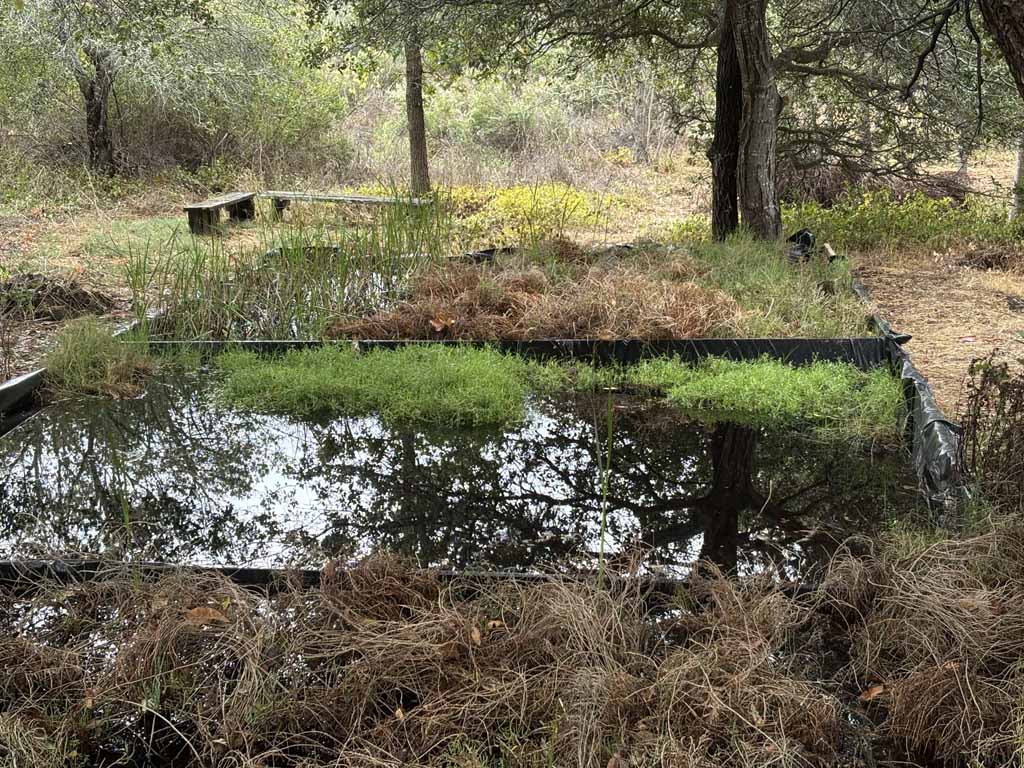
The upland areas of the restoration site were sown with native seeds including blue wildrye (Elymus glaucus) and California brome (Bromus carinatus). Coir mats, made of biodegradable coconut fiber, covered all the open soil. These mats are used in restoration projects to stabilize sloped areas susceptible to erosion, and because the fiber retains water, they are also beneficial in providing new vegetation with the necessary moisture to get established. As the grasses and forbs grow through the matting, their deep roots provide further stabilization to the streambank, in addition to wildlife habitat.
When it comes to effective habitat restoration, not just any native plant will do. Native plants must be carefully selected and installed, bearing in mind how they will develop and reproduce in a new location.
While we’ll never be able to perfectly recreate the plant community that existed along Corte Madera Creek historically, we have taken an important step that ultimately contributes to deterring erosion, improving wildlife food and habitat, and providing ecosystem services such as improved water quality and reduced flood risk. learning by actively participating in planting, mulching, and tending the garden.
Fish Rescue and Relocation in Kentfield
by Nicholas Salcedo, 2026
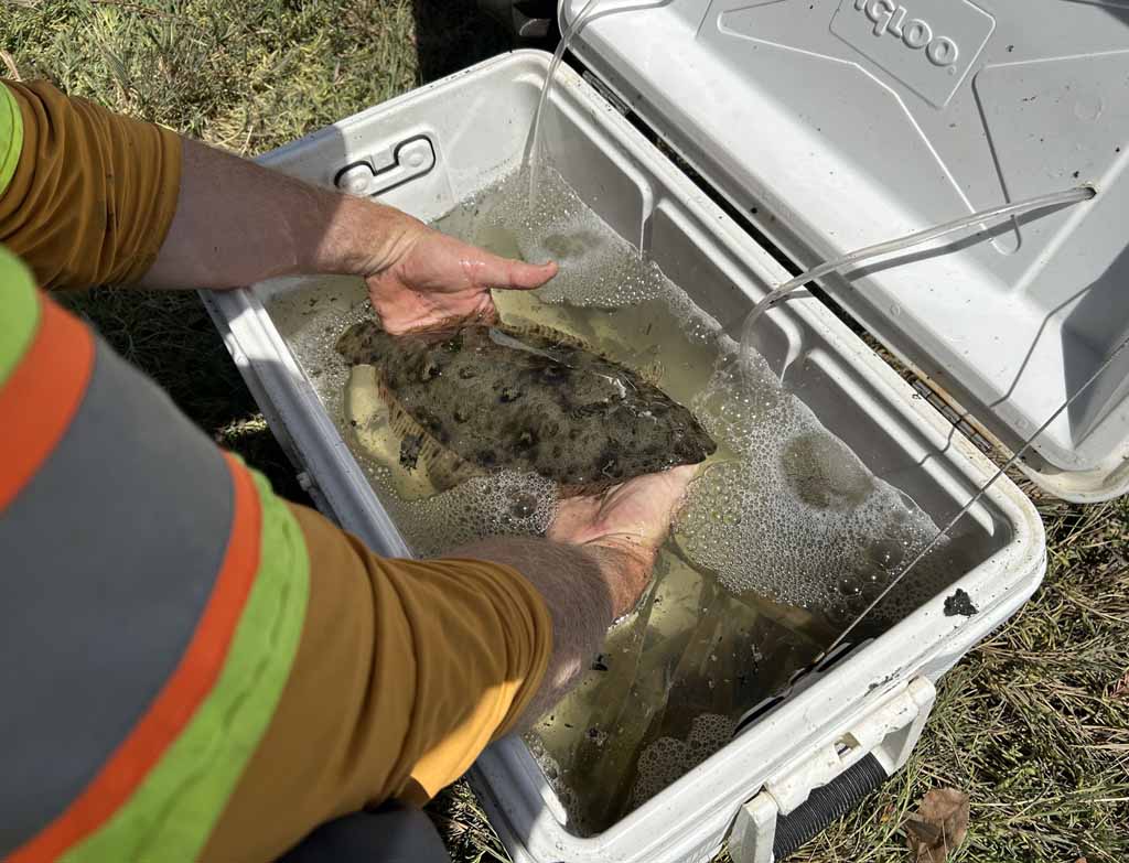
One of the benefits of the Lower College of Marin Corte Madera Creek Restoration Project, which restored and enhanced 1.8 acres of habitat by removing sections of concrete wall, was an insight into the fish that call this section of the creek home—or at least inhabit the area during the fall.
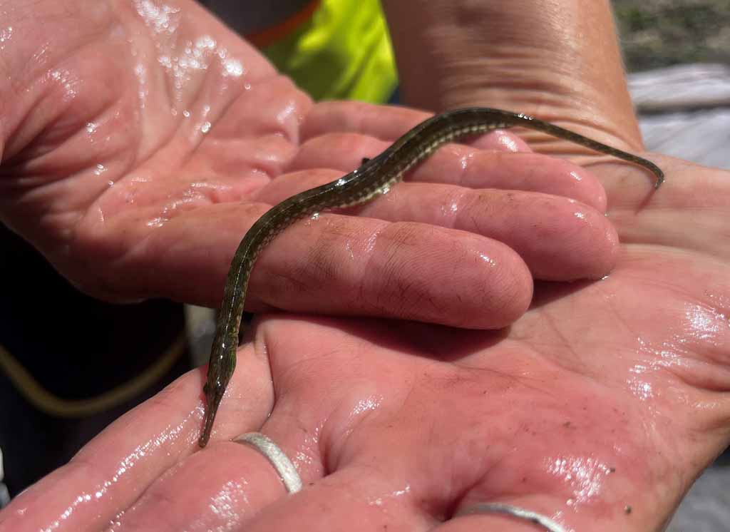
Because the project involved de-watering a section of creek, a fish rescue and relocation effort was required. On September 3–4, 2025, a team of biologists and volunteers led by Nick Brinton-McBean and Gabe Saron of WRA, Inc., captured over two thousand fish and relocated them approximately 500 feet downstream, ensuring the fish still had connectivity to downstream marshes and San Francisco Bay.
To prevent adverse impacts from the capture and relocation effort, the team followed strict protocols, such as the thorough cleaning and sanitization of all equipment, monitoring the captured fish for health, and transporting them in aerated containers to minimize stress.
Using purse seine and dip nets, the relocation team successfully moved 2,042 fish, including 191 native and 1,851 nonnative individuals. No special-status species were encountered.
The most common species relocated were inland silverside (865 individuals) and rainwater killifish (757), both nonnative fish. Inland silverside is native to eastern North America. While these small fish are eaten as a delicacy in Portugal and elsewhere, they were likely intentionally stocked in the Bay and Delta as forage for sport fish. They are also a common bait used by sport fishers.
Rainwater killifish is also native to eastern North America. It is commonly found in large numbers in fresh to brackish estuarine environments and can live in extremely salty water, feeding in the shallows on tiny crustaceans, mosquito larvae, small worms, and mollusks. They were most likely introduced during shipments of sport fish, such as largemouth bass, or during mosquito control operations or in aquarium releases.
Striped bass was another nonnative fish caught and relocated, although it was less plentiful. This popular sport fish ranges from the California-Mexico border to British Columbia. It was introduced from the Atlantic Ocean in 1879 and first released in the Carquinez Strait. It is one of the most sought-after sport fish in San Francisco Bay. An anadromous species, it moves from fresh water to saltwater and back and can be found in shallow-water areas, both sandy and rocky. Most of the fish caught by sport fishers are 12–16 inches long, but 3-foot-plus 30-pounders are not uncommon.
The most common native fish species caught and relocated were topsmelt (116), prickly sculpin (33), and starry flounder (26). Topsmelt is a species of neotropical silverside native to the eastern Pacific Ocean, ranging from British Columbia to the Gulf of California. They get their name from their habit of swimming near the surface, often schooling. Topsmelt frequent estuaries during spring and summer to spawn, the juveniles moving upstream to fresher waters and the adults to the open waters in the autumn and winter. The adults have been known to tolerate the high salinities of salt evaporation ponds. These fish can get up to a foot or so in length, feeding on algae, insect larvae and small crustaceans. The flesh is mild flavored and soft textured, but boney, with moderate fat content.
The coastal form of the prickly sculpin, native to Pacific drainages from Alaska south to Southern California, lives in rivers and swims down into brackish estuaries to breed. It is generally a bottom-dwelling species. They are reportedly scarce in poor quality waters or in urbanized watersheds with high pollutant loads, because as predators they depend on small animals that require good quality habitat. Some say they are called prickly sculpin because of the rough texture of their skin, similar to that of a cat’s tongue.
Starry flounder is found all along the coasts of the Northern Pacific, from Korea and Japan through to Alaska, Canada and down to California. It gets its name from large, starshaped scales on its eyed side. Eating a wide variety of prey, including worms, crabs, clams, sand dollars, and even sardines and sanddabs, it can grow up to 3 ft and weigh a maximum of 20 lbs. It is generally known to be of good food value to humans, although some report it only has a fair flavor. Like all flounders, when they are young, starry flounders swim around like typical fish in a vertical position, but soon they begin to tilt to one side as they swim, eventually living lying on the bottom with both eyes on the upward-facing side of the body. Preferring water with lower salinities, they spend their summers in shallow water and estuaries and move to deeper water in the winter.
This rare opportunity to inventory the fish in this section of creek allowed us to see what otherwise is mostly unseen. The fish caught and relocated highlighted the importance of the brackish, or estuarine habitat of this section of the creek. It also highlights the importance of submerged vegetation in these estuarine habitats, an integral feature in restoration design.
Sources: USGS Nonindigenous Aquatic Species (NAS) database, UC Fish Website, California Sea Grant, Pier Fishing in California, Monterey Bay Aquarium, Wikipedia.