
by Mike Swezy
The Marin Wildfire Prevention Authority (MWPA), funded by the 2020 Measure C property tax, has embarked on two largescale projects in Ross Valley to reduce risk of wildfire in adjacent neighborhoods. These projects aim to reduce vegetation in open areas to diminish wildfire intensity and allow firefighters a safer and more effective zone within which they can suppress fires.
Spurred by the 2017 wildfires in the North Bay and the increasingly destructive wildfires in the state, all of Marin’s cities and towns (except Tiburon and Belvedere), all independent fire departments, and the County of Marin, formed MWPA, a regional joint powers authority, to implement a comprehensive wildfire prevention program that includes evacuation planning and preparedness, home hardening, defensible space inspections, grants, public education, and vegetation management.
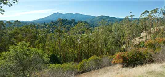
The first major vegetation management project initiated by the MWPA is the Greater Ross Valley Fuel Break Project (GRVFB). It defines a broad swath immediately adjacent to homes in a 38mile, roughly 200footwide shaded fuel break from Fairfax to Corte Madera. It is located between homes on private and public lands that cross about 1,700 parcels. The fuel reduction zone covers about 1,300 acres.
The project plan was approved by the MWPA board in June of 2022 and included mapping, modeling, project design, collaboration with partner agencies, public outreach, field surveys, and environmental compliance. Project implementation began in summer 2022 and is expected to continue through 2024.
The GRVSFB is a collaboration of MWPA, Marin County Fire Department, Ross Valley Fire Department, Kentfield Fire Protection District, and Central Marin Fire Department, MMWD and Marin County Parks. The project is funded by a $3.25 million Cal Fire grant and Measure C funds.
Actions taken to create shaded fuel breaks include removing lower limbs of trees up to about 8’ to keep ground fires from climbing into the forest canopy. Dead and down material is removed and small trees and shrubs may be thinned. Mature trees are retained to create cooler and moister ground conditions.
Limited access behind houses and the steepness of the slope of the hills surrounding Ross Valley limits the use of heavy equipment to construct fuel breaks. Therefore, most of the work is accomplished with hand crews using chainsaws and either dragging the material to a wood chipper or placing it in piles to be burned outside of fire season. Goats have been used to reduce grass fuels near communities in some locations.
The fact that California’s landscape evolved under the stewardship of Native Americans using frequent fires to create more open and fire-resilient forests is fundamental to this work. After European settlement, wildfires were suppressed and vegetation density increased. Further, homes were built in the hills, and heavily watered gardens increased wildfire fuels. In the open areas in Ross Valley, natural plant communities have been disturbed and, in many cases, invaded by nonnative French broom, eucalyptus, and acacia, thereby increasing the amount of vegetation available to wildfires. In many cases the primary activity in fuel break construction is removal of these invasives, effectively helping to restore more natural conditions.
With long-term funding from the tax measure, MWPA promises to maintain fuel breaks including follow-up removal of invasives.
The San Rafael–San Anselmo Fuel Reduction Zone project (SRSAFRZ) is a more focused project covering a 145acre stand of eucalyptus that is bounded by the Ridgewood Fire Road in the north and Red Hill next to Sir Francis Drake Blvd. on the south. The primary landowners are the Town of San Anselmo, the Cedars of Marin, Mt. Tamalpais Cemetery, and Marin County Open Space District. This eucalyptus stand is mature and particularly hazardous. A wildfire in the 70’s completely consumed the eucalyptus forest but the trees sprouted back and now it is arguably a greater wildfire threat than ever before. A wind-driven wildfire in a eucalyptus forest in this condition would generate extreme wildfire behavior and generate substantial ember production that increases fire spread.
The stated objectives of this project are to: 1) restore native habitat by thinning smaller eucalyptus, retaining a mosaic of oak, grassland, and other common native tree and shrub species; 2) selectively remove mature eucalyptus; 3) reduce overall acreage of eucalyptus stands; and 4) keep remaining eucalyptus trees spaced and maintained in a way that reduces their fire risk to neighboring and downwind communities.
Removal of eucalyptus will focus on trees less than 10” in diameter. Tree stumps will be treated with a direct application of herbicide to prevent resprouting. Under the plan most of the mature eucalyptus will remain.
The decision to retain larger trees is in part a cost consideration, and also recognizes the risk of landslides that could occur once soil-bolstering root systems decompose.
Because of the size and quantity of trees being removed, work will be accomplished using conventional cable logging and other tracked heavy equipment. Disposal of wood will be costly so that in addition to chipping and spreading on site or pile burning, larger stems may be processed on site and trucked to biomass plants or possibly burned on site using large “curtain burners” that burn in a way that minimizes smoke production.
This project was approved by the MWPA board in November 2023 and staff are developing grant proposals to augment MWPA funding for implementation.
From the outset of the MWPA there has been detailed and consistent involvement with the environmental community. Also, MWPA has had significant interaction with the general public, hosting public meetings during the planning process, and field trips to view work in progress. Work on all properties requires a written right-of-entry agreement that fosters even more detailed one-on-one conversations.
The general public and representatives of environmental organizations expressed early concern that thinning vegetation would increase invasive plant populations, that wildlife habitat structure would be reduced, and that erosion could increase post-project. The two projects covered here were evaluated using the California Vegetation Treatment Plan and Programmatic Environmental Impact Report (CalVTP), a comprehensive plan and environmental process developed by the California Board of Forestry and Fire Protection to guide implementation of vegetation management projects across the state. It includes practices and required mitigations to address potential impacts. In addition, the MWPA has adopted standard practices that in some cases are more stringent than CalVTP.
Examples of mitigations employed include conducting work outside of bird nesting seasons, protection of wood rat nests (wood rats are favored prey for the northern spotted owl), and special protection of riparian habitats. In practice most stream corridors are not included in project areas due to their inherent diminished fire risk.